COLONEL JAMES JABARA (AAO)(KAAO) 9 NE UTC–6(–5DT) N37°44.85′ W97°13.27′
1421 B NOTAM FILE AAO
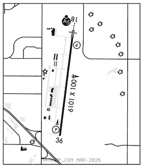
RWY18–36:H6101X100 (CONC–GRVD) S–40, D–62 PCN 15 R/B/X/T MIRL 0.3% up S
RWY 18: MALSR. PAPI(P4L)–GA 3.0° TCH 45′. Rgt tfc.
RWY 36: REIL. PAPI(P4L)–GA 3.0° TCH 45′.
SERVICE: S4 FUEL 100LL, JET A LGT ACTVT MIRL Rwy 18–36, MALSR Rwy 18, REIL Rwy 36–CTAF. FUELFor 24 hr fuel contact FBO.
AIRPORT REMARKS: Attended continuously. Migratory birds on and in vcnty of arpt. For 24 hour fuel contact FBO 316–636–9700. PPR for acft carrying Class 1 Division 1.1, 1.2 or 1.3 explosives as defined by 49 CFR 173.50. McConnell AFB 9 miles S and Beech Factory arpt 3 miles S. Beech Factory Arpt Class D airspace 1 mile S Rwy 18. Southerly and southeasterly VFR arr and dep not recommended without ATC radar svcs due to Beech factory arpt and McConnell AFB Class D airspace. VFR arr and dep recommended to rmn at or blw 2,500 MSL within 5 miles due to heavy mil tfc 3,000′ MSL. No line of sight between rwy ends. Engine runs–ups not permitted on acft ramps. Rwy 36 dsgnd calm wind rwy.
AIRPORT MANAGER: 316-946-4700
WEATHER DATA SOURCES: ASOS 134.025 (316) 636–2541.
COMMUNICATIONS: CTAF/UNICOM 122.7
®WICHITA APP/DEP CON 134.8
WICHITA CLNC DEL 125.0
AIRSPACE: CLASS E.
RADIO AIDS TO NAVIGATION: NOTAM FILE ICT.
WICHITA (H) (H) VORTACW 113.8 ICT Chan 85 N37°44.72′ W97°35.03′ 082° 17.3 NM to fld. 1472/7E.
TACAN AZIMUTH unusable:
025°–035° blo 4,000′
040°–055° byd 20 NM
147°–159° blo 4,900′
VOR unusable:
025°–035° blo 4,000′
147°–159° blo 4,400′
ILS/DME 109.55 I–AAO Chan 32(Y) Rwy 18. Class IT.