SMITHFIELD
JOHNSTON RGNL (JNX)(KJNX) 3 NW UTC–5(–4DT) N35°32.46′ W78°23.42′ 164 B TPA–1199(1035) NOTAM FILE JNX
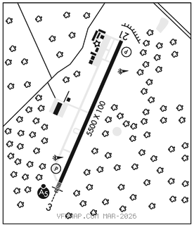
RWY 03–21: H5500X100 (ASPH) S–65, D–65 MIRL 0.3% up NE
RWY 03: MALSR. PAPI(P4L)–GA 3.0° TCH 45′. Trees.
RWY 21: REIL. PAPI(P4L)–GA 4.0° TCH 49′. Trees.
SERVICE: S4 FUEL 100LL, JET A1+ LGT ACTVT MALSR Rwy 03; REIL Rwy 21; MIRL 03–21; twy lgts–CTAF. PAPI Rwy 03 and 21 oper consly.
NOISE: Avoid overflights of housing area in tfc pat for noise abatement. Fly wider dnwnds & longer dep legs.
AIRPORT REMARKS: Attended 1300–2300Z‡. Unattended Thanksgiving and Christmas day. Deer and coyote on and invof arpt. Be alert when taxiing near south ramp/corporate hangar. Helicopter flight training ops invof arpt. Rwy 21 has +65′ unmkd p–line 2000′ fm thld left and right of cntrln. 50′ AGL twr 200′ SW of Rwy 03 cntrln. Key code aces to pilot lounge at pilot/crew ramp. Rwy 03–21 has 150 ft swy on both ends. GPU avbl.
AIRPORT MANAGER: 919-934-0992
WEATHER DATA SOURCES: AWOS–3 120.225 (919) 934–3851.
COMMUNICATIONS: CTAF/UNICOM 122.725
®RALEIGH APP/DEP CON 125.3
GCO 135.075 (RALEIGH CD and FLIGHT SERVICES)
CLEARANCE DELIVERY PHONE: For CD if Raleigh Apch una via GCO ctc Raleigh Apch at 919-380-3144.
RADIO AIDS TO NAVIGATION: NOTAM FILE RDU.
RALEIGH/DURHAM (H) (H) VORTACW 117.2 RDU Chan 119 N35°52.35′ W78°47.00′ 145° 27.6 NM to fld. 429/9W.
JURLYNDB (MHW/LOM) 263 JN N35°28.50′ W78°25.52′ 032° 4.3 NM to fld. 194/9W. NOTAM FILE JNX.NDB unmonitored 2200–1300Z‡.
NDB unusable:
Byd 15 NM
ILS/DME 111.15 I–JNX Chan 48(Y) Rwy 03. Class IB. LOM JURLY NDB. NDB unmonitored 2200–1300Z‡. ILS GS/LOC unmonitored 2200–1300Z‡. DME unmonitored. NDB unusable byd 15 NM.