MORA MUNI (JMR)(KJMR) 1 NE UTC–6(–5DT) N45°53.51′ W93°16.38′
1033 B NOTAM FILE JMR
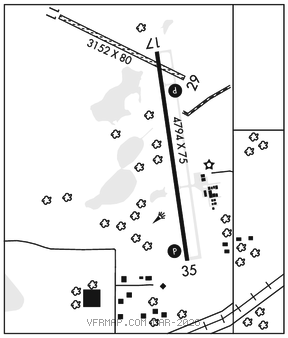
RWY 17–35: H4794X75 (ASPH) MIRL
RWY 17: REIL. PAPI(P4L)–GA 3.0° TCH 41′.
RWY 35: REIL. PAPI(P4L)–GA 3.0° TCH 40′.
RWY 11–29: 3152X80 (TURF) 1.2% UP W
SERVICE: FUEL 100LL, JET A LGT ACTIVATE REIL Rwy 17 and Rwy 35; PAPI Rwy 17 and Rwy 35–CTAF.MIRL Rwy 17–35 preset to low ints, to incr ints–CTAF.
AIRPORT REMARKS: Unattended. Waterfowl invof arpt. Ultralights on and invof arpt. Fuel avbl H24 with credit card. Rwy 11–29 mkd with yellow cones. Rwy 11–29 gravel patches and bare spots.
AIRPORT MANAGER: 320-674-4997
WEATHER DATA SOURCES: AWOS–3 123.925 (320) 679–1629.
COMMUNICATIONS: CTAF/UNICOM 122.8
®MINNEAPOLIS CENTER APP/DEP CON 121.05
CLEARANCE DELIVERY PHONE: For CD ctc Minneapolis ARTCC at 651-463-5588.
RADIO AIDS TO NAVIGATION: NOTAM FILE STC.
ST CLOUD (T) (T) VORW/DME 112.1 STC Chan 58 N45°32.96′ W94°03.52′ 055° 38.9 NM to fld. 1023/3E. VOR unmonitored.