IOWA CITY MUNI (IOW)(KIOW) 2 SW UTC–6(–5DT) N41°38.38′ W91°32.87′
684 B NOTAM FILE IOW
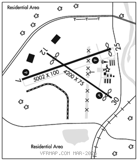
RWY 07–25: H5002X100 (CONC–GRVD) S–25, D–45 PCN 15 R/C/W/T MIRL 0.7% up SW
RWY 07: REIL. PAPI(P4L)–GA 3.5° TCH 51′. Pole. Rgt tfc.
RWY 25: REIL. PAPI(P4L)–GA 3.0° TCH 38′. Thld dsplcd 130′.
RWY 12–30: H4200X75 (CONC–GRVD) S–15, D–20 PCN 6 R/C/W/T MIRL 0.3% up NW
RWY 12: Thld dsplcd 500′. Tree. Rgt tfc.
RWY 30: REIL. PAPI(P2L)–GA 3.5° TCH 38′. Thld dsplcd 300′. Tree.
RUNWAY DECLARED DISTANCE INFORMATION
RWY 07: TORA–5002 TODA–5152 ASDA–5002 LDA–5002
RWY 25: TORA–5002 TODA–5002 ASDA–5002 LDA–4872
SERVICE: S4 FUEL 100LL, JET A LGT MIRL Rwy 07–25 and 12–30 preset low intst; to incr intst and ACTVT PAPI Rwy 07, 25 and 30; REIL Rwy 07, 25 and 30–CTAF.
NOISE: Noise abatement procedures in effect, ctc arpt mgr 319–356–5045.
AIRPORT REMARKS: Attended 1230–0230Z‡. Waterfowl and deer on and invof arpt. Glider activity on and invof arpt. Ultralight activity discouraged, RDO required. Rwy 25 designated as calm wind rwy. Numerous unlighted cranes 200′ AGL 2 NM radius of arpt. Helicopter activity 3/4 mile north of arpt invof University of Iowa Hospital. Stadium within 3 NM, check for events.
AIRPORT MANAGER: 319-356-5045
WEATHER DATA SOURCES: ASOS 128.075 (319) 339–9491.
COMMUNICATIONS: CTAF/UNICOM 122.8
RCO 122.1R 116.2T 122.3 (FORT DODGE RADIO)
®CEDAR RAPIDS APP/DEP CON 119.7 (1100–0530Z‡)
CHICAGO CENTER APP/DEP CON 132.8 (0530–1100Z‡)
CLNC DEL 119.05
RADIO AIDS TO NAVIGATION: NOTAM FILE IOW.
(VH) (H) VOR/DME 116.2 IOW Chan 109 N41°31.14′ W91°36.80′ 017° 7.8 NM to fld. 767/5E.