WILMINGTON AIR PARK (ILN)(KILN) 2 SE UTC–5(–4DT) N39°25.68′ W83°47.53′
1077 B ARFF Index–See Remarks NOTAM FILE ILN
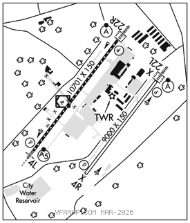
RWY 04L–22R: H10701X150 (CONC–GRVD) S–100, D–200, 2S–175, 2D–390, 2D/2D2–750 PCR 920 R/C/W/T HIRL CL No Part 121/Part 380 Ops
RWY 04L: MALSR. PAPI(P4L)–GA 3.0° TCH 62′. RVR–TMR
RWY 22R: ALSF2. TDZL. PAPI(P4L)–GA 3.0° TCH 71′. RVR–TMR 0.4% down.
RWY 04R–22L: H9000X150 (CONC–GRVD) S–100, D–200, 2S–175, 2D–390, 2D/2D2–750 PCR 900 R/D/W/T HIRL CL No Part 121/Part 380 Ops
RWY 04R: PAPI(P4L)–GA 3.0° TCH 71′. RVR–TMR 0.3% up.
RWY 22L: ALSF2. TDZL. PAPI(P4L)–GA 3.0° TCH 71′. RVR–TMR 0.4% down.
RUNWAY DECLARED DISTANCE INFORMATION
RWY 04L:TORA–10701 TODA–10701 ASDA–10701 LDA–10701
RWY 04R:TORA–9000 TODA–9000 ASDA–9000 LDA–9000
RWY 22L:TORA–9000 TODA–9000 ASDA–9000 LDA–9000
RWY 22R:TORA–10701TODA–10701 ASDA–10701 LDA–10701
SERVICE: S4 FUEL JET A OX 1, 2 LGT PAPI Rwy 04L and 22R opr consly SS–SR. All Rwy 04R–22L lgts OTS indefly. Rwy 04L and 22R PAPI unusbl byd 8 degs left & right of cntrln.
AIRPORT REMARKS: Attended continuously. Rwy 04R–22L CLOSED indefly. Class IV, ARFF Index A. Index B svc avbl. Rwy 04L–22R and Rwy 04R–22L, 90–day PPR for sked ACR ops gtr than 30 pax seats–call amgr 937–528–9891. Surface movement guidance and control system not avbl. Rwy 04L–22R has 1000′ paved area on southwest end and 200′ paved area on northeast end. Rwy 04R–22L has 200′ paved area on each end. 4 hr PPR for all tsnt acft durg oprg hrs and aft hrs–call 866–931–2337. Non comm lndg fee.
AIRPORT MANAGER: 937-366-2114
WEATHER DATA SOURCES: ASOS (937) 383–7334
COMMUNICATIONS: D–ATIS 124.925
®COLUMBUS APP/DEP CON 118.85
TOWER 119.475 GND CON 121.6 CLNC DEL 128.85
CLEARANCE DELIVERY PHONE: For CD ctc Columbus Apch at 614-338-8537.
AIRSPACE: CLASS D.
RADIO AIDS TO NAVIGATION: NOTAM FILE ILN.
MIDWEST (T) (T) VORW/DME 112.9 MXQ Chan 76 N39°25.78′ W83°48.07′ at fld. 1052/4W.
VOR unusable:
051°–200°
201°–244° byd 10 NM blo 10,000′
245°–255° byd 20 NM blo 10,000′
256°–297° byd 18 NM blo 10,000′
298°–359°
300°–050° wi 3 NM
360°–022° blo 6,000′
360°–022° byd 18 NM blo 10,000′
DME unusable:
003°–024°
282°–302° byd 18 NM blo 4,000′
303°–309°
310°–320° byd 18 NM blo 6,000′
335°–340° byd 18 NM blo 6,000′
CUBLA NDB (LOMW) 299 HW N39°21.21′ W83°52.55′ 048° 5.9 NM to fld. 996/7W.
AIRBO NDB (MHW/LOM) 407 IL N39°29.58′ W83°44.29′ 220° 4.6 NM to fld. 10507W.
ILS 110.7 I–HWM Rwy 04L. Class IE. LOM CUBLA NDB.
ILS 110.7 I–ILN Rwy 22R. Class IIIE. LOM AIRBO NDB.
COMM/NAV/WEATHER REMARKS: Emergency frequency 121.5 not avbl at twr.