HAYWARD
SAWYER CO (HYR)(KHYR) 2 NE UTC–6(–5DT) N46°01.52′ W91°26.66′ 1216 B NOTAM FILE HYR
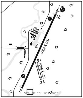
RWY 03–21:H5002X100 (ASPH–GRVD) S–74, D–106, 2S–82, 2D–173 PCR 290 F/C/X/T HIRL
RWY 03: REIL. PAPI(P4L)–GA 3.0° TCH 34′. Fence.
RWY 21: MALSR. PAPI(P4R)–GA 3.0° TCH 45′. Trees.
RWY 16–34: 1088X120 (TURF)
RWY 16: Trees.
RWY 34: Trees.
SERVICE: FUEL 100LL, JET A+ LGT ACTVT MALSR Rwy 21; REIL Rwy 03; PAPI Rwy 03 and 21; HIRL Rwy 03–21–CTAF. SS–SR HIRL Rwy 03–21 preset to low; to incr intst–CTAF.
AIRPORT REMARKS: Attended May–Oct 1400–0000Z‡, Nov–Apr 1400–2300Z‡. Rwy 16–34 CLOSED Dec 1 thru Apr 15. Birds on & invof arpt. Arpt cond unmon 2300–1400Z‡. Rwy end 16 and Rwy end 34 mkd with yellow cones.
AIRPORT MANAGER: 715-634-4624
WEATHER DATA SOURCES: ASOS 118.4 (715) 634–6138.
COMMUNICATIONS: CTAF/UNICOM 122.8
®MINNEAPOLIS CENTER APP/DEP CON 126.45
CLEARANCE DELIVERY PHONE:For CD if una via freq ctc Minneapolis ARTCC at 651-463-5588.
RADIO AIDS TO NAVIGATION: NOTAM FILE HYR.
HAYWARD (L) DME 113.4 HYR Chan 81 N46°01.14′ W91°26.78′ at fld. 1208.
DME unusable:
Blw 10,000′
Byd 20 NM
ILS/DME 108.5 I–HTY Chan 22 Rwy 21. Class IB. Unmonitored.