HOLDREGE
BREWSTER FLD (HDE)(KHDE) 2 NE UTC–6(–5DT) N40°27.11′ W99°20.16′ 2314 B NOTAM FILE HDE
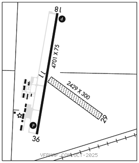
RWY 18–36: H4701X75 (ASPH–CONC) S–30 MIRL
RWY 18: REIL. PAPI(P2L)–GA 3.0° TCH 40′. Tn center pivot irrigator rotates through apch during irrigation season.
RWY 36: REIL. PAPI(P2L)–GA 3.0° TCH 40′.
RWY 11–29: 2429X300 (TURF)
SERVICE: S4 FUEL 100LL, JET A OX3 LGT MIRL Rwy 18–36 preset on low ints, to increase ints and ACTIVATE REIL and PAPI Rwy 18 and Rwy 36–CTAF.
AIRPORT REMARKS: Attended Mon–Fri 1400–2300Z‡. Waterfowl invof arpt. 100LL 24 hr self svc fuel avbl via credit card system. Call for Jet A service, for svc and attendant after hrs call 308–995–7895, if no answer, call 308–991–5803. Extensive crop spraying ops invof arpt Apr thru Aug. Rwy 11–29 not plowed winter months. Rwy 18 designated calm wind rwy. Rwy 11–29 marked; boundary cones on rwy ends. Rwy 18–36 south 3100′ and center 50′ asph. Aviators breathing oxygen 2000 psi–bottles can be topped off. Rwy 18 cntr pivots rotn thru apch can create slope as low 15:1 durg irrigation season.
AIRPORT MANAGER: (308) 991-3641
WEATHER DATA SOURCES: AWOS–3 121.325 (308) 995–6433.
COMMUNICATIONS: CTAF/UNICOM 122.8
®DENVER CENTER APP/DEP CON 132.7
CLEARANCE DELIVERY PHONE: For CD ctc Denver ARTCC at 303-651-4257.
RADIO AIDS TO NAVIGATION: NOTAM FILE EAR.
KEARNEY (L) VORW 111.2 EAR N40°43.54′ W99°00.31′ 218° 22.3 NM to fld. 2127/5E.
HASTINGS (L) DME 108.8 HSI Chan 25 N40°36.27′ W98°25.78′ 258° 42.5 NM to fld. 1957. NOTAM FILE HSI.