THREE RIVERS MUNI/DR HAINES (HAI)(KHAI) 2 NE UTC–5(–4DT) N41°57.58′ W85°35.58′
823 B TPA–1823(1000) NOTAM FILE HAI
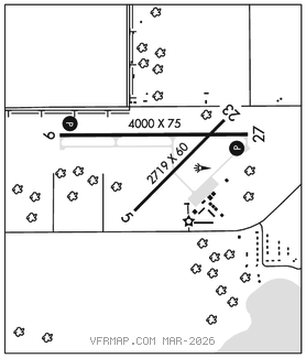
RWY 09–27: H4000X75 (ASPH) S–26, D–30 MIRL
RWY 09: REIL. PAPI(P4L)–GA 3.0° TCH 25′. Trees.
RWY 27: REIL. PAPI(P4L)–GA 4.0° TCH 34′. Trees.
RWY 05–23: H2719X60 (ASPH) S–16 MIRL
RWY 05: Road.
RWY 23: Road.
SERVICE: S4 FUEL 100LL, JET A LGT ACTVT REIL Rwy 09 & 27; PAPI Rwy 09 & 27; MIRL Rwy 05–23 & 09–27–CTAF.
AIRPORT REMARKS: Unattended. Deer and large birds on and invof arpt. Possibility of crop irrigation equipment operating NE apch to Rwy 23. Radio controlled airplanes operate 1/2 mile NW of Rwy 09. Snow plowing second priority, call 269–273–1845 AMGR to confirm conds. Admin bldg access, 5–3–2–1, or 1–2–0–0. Rwy 05 15′ vertical clnc over road waived by FAA (10/06/2009 ALP approval letter). Rwy 23 15′ vertical clnc over road is waived by FAA.
AIRPORT MANAGER: 269-273-1845
WEATHER DATA SOURCES: AWOS–3P 119.975 (269) 273–6705.
COMMUNICATIONS: CTAF/UNICOM 122.8
®GREAT LAKES APP/DEP CON 121.2 (1030–0500Z‡)
®CHICAGO CENTER APP/DEP CON 127.55 (0500–1030Z‡)
CLEARANCE DELIVERY PHONE: For CD ctc Great Lakes Apch at 269-459-3344, when Apch clsd ctc Chicago ARTCC at 630-906-8921.
RADIO AIDS TO NAVIGATION: NOTAM FILE IRS.
STURGIS NDB (MHW) 382 IRS N41°48.79′ W85°26.03′ 325° 11.3 NM to fld. 923/4W.