GWINNER/ROGER MELROE FLD (GWR)(KGWR) 1 SE UTC–6(–5DT) N46°13.10′ W97°38.60′
1266 B NOTAM FILE GFK
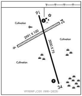
RWY 16–34: H5000X75 (CONC–GRVD) S–14, D–19 MIRL
RWY 16: REIL. PAPI(P2L)–GA 3.0° TCH 25′.
RWY 34: REIL. PAPI(P2L)–GA 3.0° TCH 25′.
RWY 06–24: 2991X100 (TURF) 0.5% up SW
SERVICE: FUEL 100LL, JET A LGT ACTIVATE REIL Rwy 16 and Rwy 34, PAPI Rwy 16 and Rwy 34, and MIRL Rwy 16–34 –CTAF.
AIRPORT REMARKS: Unattended. Deer and birds on and invof arpt. Self svc fuel avbl 24 hrs with credit card. Rwy 06–24 CLOSED winter months. Rwy 16 +480′ lgtd tower 17,500′ fm thld 3000′ right of extended centerline. Cfm winter conds and Rwy 16–34 sn removal call 701–680–8000; 701–308–0169; city maint 701–680–0081. Rwy 06–24 no thld or rwy edge markers.
AIRPORT MANAGER: 701-680-8000
WEATHER DATA SOURCES: AWOS–3 118.325 (701) 678–6801.
COMMUNICATIONS: CTAF/UNICOM 122.7
®MINNEAPOLIS CENTER APP/DEP CON 127.35
CLEARANCE DELIVERY PHONE: For CD ctc Minneapolis ARTCC at 651-463-5588.
RADIO AIDS TO NAVIGATION: NOTAM FILE FAR.
FARGO (VH) (DH) VORW/DME 116.2 FAR Chan 109 N46°45.20′ W96°51.08′ 217° 45.9 NM to fld. 909/9E.