GEORGETOWN EXEC (GTU)(KGTU) 3 N UTC–6(–5DT) N30°40.73′ W97°40.76′
790 B NOTAM FILE GTU
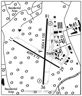
RWY 18–36: H5004X100 (ASPH–GRVD) S–30, D–60 MIRL 0.8% up N
RWY 18: REIL. PAPI(P4L)–GA 3.0° TCH 35′. Trees.
RWY 36: REIL. PAPI(P4L)–GA 3.0° TCH 50′. Trees. Rgt tfc.
RWY 11–29: H4099X75 (ASPH) S–12.5 MIRL 0.7% up NW
RWY 11: Tree.
RWY 29: Tree. Rgt tfc.
SERVICE: S4 FUEL 100LL, JET A1+ OX 1, 2, 3, 4 LGT Aftr twr hrs, MIRL Rwy 18–36 preset low intst; to incr intst and ACTVT REILS Rwy 18–36; MIRL Rwy 11–29–CTAF. .
AIRPORT REMARKS: Attended 1300Z‡–0100Z‡. Deer on and in vicinity of arpt. Mil hel opns prohibited btn 0300–1300Z‡. Rwy 18–36 hel skid ldg prohibited to prevent dmg to groovrd sfc. Portions of Twy F not visible from tower. NOTE: See Special Notices–Aerobatic Practice Area.
AIRPORT MANAGER: 512-930-8464
WEATHER DATA SOURCES: AWOS–3PT (512) 869–3430 LAWRS.
COMMUNICATIONS: CTAF 120.225 ATIS 118.6 UNICOM 123.0
®AUSTIN APP/DEP CON 119.0
TOWER 120.225 (1300–0400Z‡) GND CON 119.125
CLNC DEL 119.125 CLNC DEL 121.1 (when twr clsd)
CLEARANCE DELIVERY PHONE: For CD ctc Austin Apch at 512-369-7865.
AIRSPACE: CLASS D svc 1300–0400Z‡; other times CLASS E.
RADIO AIDS TO NAVIGATION: NOTAM FILE AUS.
CENTEX (VH) (H) VORTACW 112.8 CWK Chan 75 N30°22.71′ W97°31.79′ 331° 19.6 NM to fld. 593/6E.
VOR unusable:
180°–190° byd 40 NM
200°–210° byd 40 NM