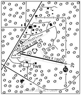
GAINESVILLE RGNL (GNV)(KGNV) 3 NE UTC–5(–4DT) N29°41.40′ W82°16.31′
151 B Class I, ARFF Index B NOTAM FILE GNV

RWY 11–29: H7504X150 (ASPH–GRVD) S–118, D–195, 2S–175, 2D–331, 2D/2D2–796 PCR 480 F/B/X/T HIRL 0.6% up W
RWY 11: REIL. PAPI(P4L)–GA 3.0° TCH 54′. RVR–R Trees.
RWY 29: MALSR. PAPI(P4R)–GA 3.0° TCH 55′. RVR–T Trees.
RWY 07–25: H4158X100 (ASPH–GRVD) S–83, D–137, 2S–175, 2D–227 PCR 320 F/B/X/T MIRL 0.5% up SW
RWY 07: PAPI(P4L)–GA 3.0° TCH 44′. Trees.
RWY 25: PAPI(P4L)–GA 3.0° TCH 42′. Trees.
SERVICE: S4 FUEL 100, JET A OX 1, 3 LGT When ATCT clsd, ACTVT MALSR Rwy 29; MIRL Rwy 07–25; HIRL Rwy 11–29–CTAF.
AIRPORT REMARKS: Attended continuously. Wildlife on and invof arpt. High density migratory birds dur dalgt hrs invof all rwys. Rwy 07–25 acr NA. Arpt sfc cond not mntd btw 0430–0900Z‡ dly. Banner towing na exc 72 hr PPR–amgr. Portions of Rwy 07–25 and NE 1000′ of Twy A not vsb fm ATCT; blocked by VORTAC bldg. Rwy 07–25 not avbl for sked acr ops with more than 9 pax seats or unsked acr at least 31 pax seats.When ATCT clsd, acft more than 12,500 lbs ctc FBO for prkg instr prior to exiting Twy A due to ireg pavement strengths–352–335–4681. Twy B lmtd to 75,000 lb or blw; others PPR. Twy C lmtd to 120,000 lb or blw; others PPR. Rwy 11–29 grvd full length x 130′ wide ctr portion. GA ramp lmtd to acft 110,000 lbs or blw; others PPR. Rwy 11–29 mrkgs on W end are not std due to mrkgs not fully removed/ghosting.
AIRPORT MANAGER: 352-373-0249
WEATHER DATA SOURCES: ASOS 127.15 (352) 335–8672.
COMMUNICATIONS: CTAF 119.55 ATIS 127.15 UNICOM 122.95
GATORS RCO 122.2 (GAINESVILLE RADIO)
®JACKSONVILLE APP/DEP CON 118.175 (10,000′ and blw)
TOWER 119.55 (1145–0330Z‡) GND CON 121.7
CLEARANCE DELIVERY PHONE: For CD if una to ctc on FSS freq, ctc Jacksonville Apch at 904-741-0284.
AIRSPACE: CLASS D svc 1145–0330Z‡; other times CLASS E.
RADIO AIDS TO NAVIGATION: NOTAM FILE GNV.
GATORS (L) (L) VORTACW 116.2 GNV Chan 109 N29°41.53′ W82°16.38′ at fld. 128/4W.
VORTAC unusable:
Byd 25 NM blo 3,000′
ILS 111.3 I–GNV Rwy 29. Class IT.