GREAT BARRINGTON (GBR)(KGBR) 2 W UTC–5(–4DT) N42°11.05′ W73°24.19′
739 B NOTAM FILE BTV
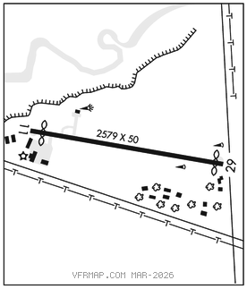
RWY 11–29: H2579X50 (ASPH) S–8 LIRL
RWY 11: REIL. Thld dsplcd 170′. Trees.
RWY 29: Thld dsplcd 75′. Trees.
SERVICE: S4 FUEL 100LL OX 3 LGT ACTVT REIL Rwy 11; LIRL Rwy 11–29–121.6.
AIRPORT REMARKS: Attended 1300–2200Z‡. Wildlife on and invof arpt. Practice VFR GPS Rwy 11 not authorized when Rwy 29 is in use for student tfc. Touch and go ldg not authorized. Rwy 11 lgtd thr relctd 170′, 2409′ of rwy usbl for ngt ops. Compass rose adzy only, not crtfd. Cold temperature airport. Altitude correction required at or below –19C. Landing fee, AVcard not acptd.
AIRPORT MANAGER: 413-528-1010
COMMUNICATIONS: CTAF/UNICOM 122.8
®ALBANY APP/DEP CON 132.825
CLEARANCE DELIVERY PHONE: For CD ctc Albany Apch at 518-862-2299.
RADIO AIDS TO NAVIGATION: NOTAM FILE BTV.
CHESTER (L) (L) VORW/DME 115.1 CTR Chan 98 N42°17.48′ W72°56.96′ 266° 21.2 NM to fld. 160013W.
VOR unusable:
248°–274°