FORT WAYNE
FORT WAYNE INTL (FWA)(KFWA) P (ANG) 7 SW UTC–5(–4DT) N40°58.71′ W85°11.71′ 815 B ARFF Index–See Remarks NOTAM FILE FWA
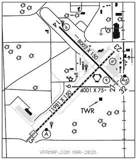
RWY 05–23: H11981X150 (ASPH–CONC–GRVD) S–120, D–203, 2D–357, 2D/2D2–847 PCR 820 R/B/W/T HIRL CL
RWY 05: ALSF2. TDZL. RVR–TMR
RWY 23: REIL. PAPI(P4L)–GA 3.0° TCH 76′. RVR–TMR Railroad. 0.3% down.
RWY 14–32: H8002X150 (ASPH–CONC–GRVD) S–120, D–189, 2D–326, 2D/2D2–799 PCR 1089 R/B/W/T HIRL
RWY 14: REIL. PAPI(P4L)–GA 3.0° TCH 53′. RVR–R Tree.
RWY 32: MALSR. PAPI(P4L)–GA 3.0° TCH 76′. RVR–T Railroad.
RWY 09–27: H4001X75 (ASPH–CONC) S–100, D–190, 2D–215, 2D/2D2–430 PCR 779 R/B/W/T No Part 121/Part 380 Ops
RUNWAY DECLARED DISTANCE INFORMATION
RWY 05: TORA–11981 TODA–11981 ASDA–11981 LDA–11981
RWY 09: TORA–4001 TODA–4001 ASDA–4001 LDA–4001
RWY 14: TORA–8001 TODA–8001 ASDA–8001 LDA–8001
RWY 23: TORA–11981 TODA–11981 ASDA–11981 LDA–11981
RWY 27: TORA–4001 TODA–4001 ASDA–4001 LDA–4001
RWY 32: TORA–8001 TODA–8001 ASDA–8001 LDA–8001
ARRESTING GEAR/SYSTEM
RWY 14 HOOK BAK–12B(B) (1650 FT). BAK–12(B) (1332 FT). RWY 32
SERVICE: S4 FUEL 100LL, JET A, A+ OX 3 MILITARY– JASU 2(A/M32A–86D) 6(M32A–60) FUEL (NC–100LL, A–Callout fee 0400–1000Z‡.) FLUID LPOX LOX OIL O–148(Mil) SOAP
AIRPORT REMARKS: Attended 1000–0400Z‡. Aft hr svc–260–747–2624. Birds on and invof arpt. Class I, ARFF Index B. ARFF Index C avbl upon req–260–747–2624. Twy B arm/dearm area restricted to military acft. Twy M & East ramp mil use only, otr by request–ANG 260–478–3202. Twy B/B, 1/B, 2/E & K clsd to acft with wingspans 79′ or gtr and with dual wheel type lndg gear in excess of 50,000 lbs. A–GEAR for lcl 122FW only, PPR DSN 778–3202/3203 C800–842–3104 extn 202/203. User fee arpt.
MILITARY REMARKS: ANG Prk ramp nstd mrk incl solid white wingtip clnc lines both sides of txl lctd btn E and W of bldg 800 and mult white boxes for acft grd eqpt and munitions storage area. Unuse pavement for tax lctd cntr of apn west of rstd area–Ops for info.
AIRPORT MANAGER: 260-747-4146
WEATHER DATA SOURCES: ASOS (260) 209–0224
COMMUNICATIONS: ATIS 121.25 UNICOM 122.95
RCO 122.5 (TERRE HAUTE RADIO)
®APP/DEP CON 127.2 (SW/NW of active rwy) 132.15 (SE/NE of active rwy) 135.325
TOWER 119.1 GND CON 121.9 CLNC DEL 124.75 CMD POST 138.625
AIRSPACE: CLASS C svc ctc APP CON.
RADIO AIDS TO NAVIGATION: NOTAM FILE FWA.
(VH) (H) VORTACW 117.8 FWA Chan 125 N40°58.74′ W85°11.28′ at fld. 793/6W.
DME unusable:
060°–070° byd 6 NM blo 4,000′
TACAN AZIMUTH unusable:
060°–070° byd 6 NM blo 4,000′
240°–245°
VOR unusable:
005°–016° byd 40 NM
017°–024° byd 40 NM blo 7,500′
017°–024° byd 52 NM
025°–035° byd 65 NM
090°–095° blo 5,800′
170°–199° byd 40 NM
233°–238° byd 40 NM
239°–246° byd 20 NM
256°–270° byd 40 NM
271°–274°
275°–300° blo 12,500′
331°–353° byd 50 NM
354°–004° byd 40 NM blo 4,000′
354°–004° byd 52 NM
ILS 111.9 I–HVD Rwy 05. Class IIE. OM unmonitored.
ILS/DME 109.9 I–FWA Chan 36 Rwy 32. Class IE.
ASR
COMM/NAV/WEATHER REMARKS: APP CON sectorization based upon Fort Wayne rwy usage.