FLYING CLOUD (FCM)(KFCM) 11 SW UTC–6(–5DT) N44°49.65′ W93°27.51′
906 B NOTAM FILE FCM
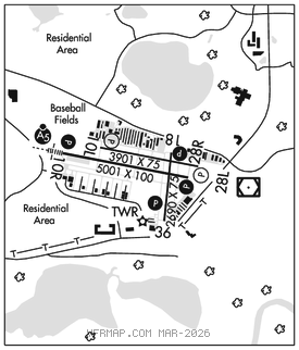
RWY 10R–28L: H5001X100 (ASPH–GRVD) S–30, D–60 HIRL
RWY 10R: MALSR. PAPI(P4L)–GA 3.0° TCH 42′. Tree. Rgt tfc.
RWY 28L: REIL. PAPI(P4L)–GA 3.0° TCH 44′.
RWY 10L–28R: H3901X75 (ASPH) S–12.5 MIRL
RWY 10L: REIL. PAPI(P4L)–GA 3.0° TCH 39′.
RWY 28R: REIL. PAPI(P4L)–GA 3.0° TCH 38′. Rgt tfc.
RWY 18–36: H2690X75 (ASPH) S–12.5 MIRL
RWY 18: REIL. PAPI(P4L)–GA 3.5° TCH 45′. Tank.
RWY 36: REIL. PAPI(P4L)–GA 3.0° TCH 27′. Fence.
SERVICE: S4 FUEL 100LL, JET A OX 3, 4 LGT When ATCT clsd ACTVT or incr intst MALSR Rwy 10R; REIL Rwy 28L, 18, and 36; PAPI Rwy 10R, 28L, 18, and 36; HIRL Rwy 10R–28L; MIRL Rwy 18–36–CTAF. Rwy 36 PAPI unusable byd 6° left of cntrln.
AIRPORTREMARKS: Attended continuously. Deer, birds, and wildlife on and invof arpt. Jet A ldg fee, ctc FBO. Rwy 10L–28R CLOSED when twr clsd. Arpt CLOSED to jets not meeting FAR 36, jet training and acft with certificated MGTOW higher than 60,000 lbs. Maintenance run–ups are prohibited between 0400–1300Z‡. Ultralight ops prohibited. When twr clsd, snow removal operators monitor 119.15. Rwy 10R is calm wind rwy when twr clsd. Twy A clsd east of Baron Lane to acft with wingspans 54′ or greater. Twy D clsd from Twy D2 to apch end Rwy 36 to acft with wingspans of 66′ or greater. Twy D btn D1 and D2 clsd to acft with wingpans 48′ or greater. Txl G clsd to wingspans gtr than 43 ft. Txl H clsd to wingspans gtr than 40 ft. Rwy incursion risk – pilots are reminded to review arpt Hot Spot info bfr txg for dep & bfr ldg. See TPP Arpt Diagram & Chart Suppl sxn on Hot Spots for addn info. Wrong rwy arr risk, closely aligned parl rwys. See TPP Arpt Diagram. Ldg fee. NOTE: See Special Notices–Arrival Alert.
AIRPORT MANAGER: 952-944-1035
WEATHER DATA SOURCES: ASOS (952) 941–4156
COMMUNICATIONS: CTAF 119.15 ATIS 124.9 UNICOM 122.95
®MINNEAPOLIS APP/DEP CON 134.7
MINNEAPOLIS CLNC DEL 121.7 (When twr closed)
TOWER 119.15 125.2 (1200–0300Z‡, 1st Sun in Nov–2nd Sat in Mar; 1200–0400Z‡, 2nd Sun in Mar–1st Sat in Nov.)
GND CON 121.7
AIRSPACE: CLASS D svc 1200–0300Z‡ 1st Sun in Nov–2nd Sat in Mar, 1200–0400Z‡ 2nd Sun in Mar–1st Sat in Nov; other times CLASS E..
RADIO AIDS TO NAVIGATION: NOTAM FILE FCM.
(L) (L) VORW/DME 117.7 FCM Chan 124 N44°49.52′ W93°26.56′ at fld. 9001E.
VOR unusable:
290°–305° blo 4,000′
DME unusable:
290°–305° blo 4,000′
ILS 109.7 I–FCM Rwy 10R. Class IT. Glideslope unusable byd 5° right of course. Unmonitored when ATCT clsd. Autopilot cpd apchs NA blw 1,425′ MSL.