WHEATON MUNI (ETH)(KETH) 3 SW UTC–6(–5DT) N45°46.83′ W96°32.63′
1023 B TPA–1999(976) NOTAM FILE ETH
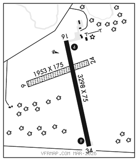
RWY 16–34: H3298X75 (ASPH) MIRL
RWY 16: PAPI(P2L)–GA 3.0° TCH 25′.
RWY 34: PAPI(P2L)–GA 3.0° TCH 25′.
RWY 06–24: 1953X175 (TURF)
SERVICE: LGT Rwy 16–34 MIRL preset to low intst. To incr intst and ACTVT PAPI Rwy 16–34–CTAF. PAPI Rwy 34 unusable byd 8° left of course.
AIRPORT REMARKS: Unattended. Rwy 06–24 not plowed winter months. Rwy 06 marked with yellow cones.
AIRPORT MANAGER: 320-563-4110
WEATHER DATA SOURCES: AWOS–3 118.775 (320) 563–4975.
COMMUNICATIONS: CTAF/UNICOM 122.8
MORRIS RCO 122.2 (PRINCETON RADIO)
MINNEAPOLIS CENTER APP/DEP CON 126.1
CLEARANCE DELIVERY PHONE: For CD ctc Minneapolis ARTCC at 651-463-5588.
RADIO AIDS TO NAVIGATION: NOTAM FILE MOX.
MORRIS (T) (T) VORW/DME 109.6 MOX Chan 33 N45°33.93′ W95°58.16′ 293° 27.4 NM to fld. 11305E. VDME unmonitored.