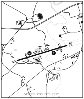
BLAIRSVILLE (DZJ)(KDZJ) 3 SW UTC–5(–4DT) N34°51.27′ W83°59.84′
1907 B NOTAM FILE MCN

RWY 08–26: H5004X100 (ASPH) S–20, D–39 MIRL 1.0% up W
RWY 08: PAPI(P2L)–GA 3.31° TCH 40′. Thld dsplcd 987′. Trees.
RWY 26: PAPI(P2L)–GA 3.54° TCH 56′. Thld dsplcd 685′. Trees.
RUNWAY DECLARED DISTANCE INFORMATION
RWY 08: TORA–5004 TODA–5004 ASDA–5004 LDA–4017
RWY 26: TORA–5004 TODA–5004 ASDA–5004 LDA–4319
SERVICE: FUEL 100LL, JET A+ LGT Actvt PAPI Rwy 08 and 26; MIRL Rwy 08–26–CTAF. VGSI unusbl byd 1.3 NM due to trrn.
AIRPORT REMARKS: Attended 1300–2200Z‡. Wildlife incldg deer and geese, invof rwys and twys. A+ Fuel avbl dur opr hrs 1300–2300Z‡. 100LL Fuel located on north side of rwy. Rwy 08–26 slps downhill 1.5 pct East.
AIRPORT MANAGER: 706-745-4307
WEATHER DATA SOURCES: AWOS–3PT 119.325 (706) 745–9271. Cig not rprtd.
COMMUNICATIONS: CTAF/UNICOM 122.8
®ATLANTA CENTER APP/DEP CON 134.8
CLEARANCE DELIVERY PHONE: For CD ctc Atlanta ARTCC at 770-210-7692.
RADIO AIDS TO NAVIGATION: NOTAM FILE MCN.
HARRIS (L) TACAN Chan 35 HRS (109.8) N34°56.58′ W83°54.94′ 217° 6.7 NM to fld. 3658/0E.