DULUTH
DULUTH INTL (DLH)(KDLH) P (ANG) 5 NW UTC–6(–5DT) N46°50.52′ W92°11.59′ 1428 B AOE ARFF Index–See Remarks NOTAM FILE DLH

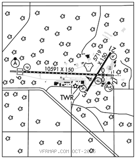
RWY 09–27: H10591X150 (CONC–GRVD) S–120, D–185, 2D–320, 2D/2D2–763 PCR 570 R/B/W/T HIRL CL
RWY09: ALSF2. TDZL. PAPI(P4L)–GA 3.0° TCH 70′. RVR–TMR Tree.
RWY 27: MALSR. PAPI(P4L)–GA 3.0° TCH 91′. RVR–TMR Thld dsplcd 529′. Tree.
RWY 03–21: H5719X150 (ASPH–GRVD) S–101, D–168, 2D–282 PCR 400 F/B/X/T MIRL
RWY 03: REIL. PAPI(P4L)–GA 3.0° TCH 39′. Tree.
RWY 21: REIL. PAPI(P4L)–GA 3.0° TCH 37′. Tree.
LAND AND HOLD–SHORT OPERATIONS
LDG RWY HOLD–SHORT POINT AVBL LDG DIST
RWY 09 03–21 8950
RUNWAY DECLARED DISTANCE INFORMATION
RWY 03: TORA–5719 TODA–5719 ASDA–5719 LDA–5719
RWY 09: TORA–10591 TODA–10591 ASDA–10062 LDA–10062
RWY 21: TORA–5719 TODA–5719 ASDA–5719 LDA–5719
RWY 27: TORA–10591 TODA–10591 ASDA–10591 LDA–10062
ARRESTING GEAR/SYSTEM
RWY 09 TYPE H BAK–12B(B) 1470 FT. TYPE H BAK 12B(B) 2544 FT. RWY 27
SERVICE: S4 FUEL 100LL, JET A, J8 OX 1, 2, 3, 4 MILITARY–JASU 9(AM32A–60) 2(A/M32A–86) 2(MC–11) 6(MC–2A) (MIL) FUEL A+, J8 (C218–727–2911). (NC–100LL, A). A++(MIL) (ANG, C218–788–7340.) FLUID De–Ice LHOX LHNIT
OIL O–148(MIL) JOAP
AIRPORT REMARKS: Attended continuously. Birds on and invof arpt. J8 avbl at both civilian and military fueling facilities. High speed military jet traffic not on ADS–B operating in and above Class D airspace from 3000′ to 11,500′ MSL ctc DLH app for trfc adzys for transit rcmdd. When Rwy 03–21 is in use Twy C north of Rwy 09–27 may be restricted by air traffic control to acft with wingspans less than 49′. Windshear/downdrafts final apch Rwy 27. Twy C btwn A and D clsd 1 Oct thru 30 Apr. Taxi lane `G′ may be used as an alternate taxi route. Flight Notification Service (ADCUS) available. For mil tsnt acft prkg, rflg, and ser off ANG ctc FBO C218–727–2977 H24. Radar See Terminal Flip for Radar Minima. Class I, ARFF Index D. ARFF Index D avbl H24 with 2 hr PPR–ctc ANG 218–788–7434. Acft deice type 1 and 4 fluid avbl–ctc FBO C218–727–2911. US Cust intl AOE (no fees) avbl H24 C218–720–5203 then press 0. Cust clearing lctd at FBO. Ldg fee for all coml acft and all acft over 12500 lb max ldg wt exc acft oprd or chtrd by the US Govt or the State of Minnesota.
MILITARY REMARKS:CAUTION: Bird hazard (phase II conditions) exists during 1 Sep through 31 Oct. Ctc SOF/Afld Manager/Comd Post for info ANG PPR all acft. Opr 1200–2130Z‡ Mon–Fri, exc hol and flex days (Ltd opr hr and trans svc avbl). Ctc Alfd Mgmt DSN 825–7252, C218–788–7252, Ops desk DSN 852–7399, C218–788–7399, Comd Post DSN 825–73707371, C218–788–73707371. Ftr acft and C12/C21 cargo acft may enter ANG Ramp via Twy E or Twy H. All other non–ftr acft use Twy F to enter ANG Ramp. Per Giant report, Twy F currently rstd to only C17/C130 acft. All other cargo AMC acft must park at Midfield Ramp. All tran acft will ctc Comd Post 15 min prior to ldg. Tran acft will ctc Comd Post before engine startup and before taxi. No svc avbl when wind chill exceeds or is forcast to exceed –30F. For RCR info, afld status and crash rescue capability ctc Comd Post or twr. Nonstd mrk for alert/maint veh, acft gnd eqpt prk spots.
AIRPORT MANAGER: 218-727-2968
WEATHER DATA SOURCES: ASOS (218) 208–0194
COMMUNICATIONS: ATIS 124.1 270.1 UNICOM 122.95 PTD 288.9
RCO 122.5 (PRINCETON RADIO)
®APP/DEP CON 125.45 233.7
TOWER 118.3 257.8 GND CON 121.9 348.6
ANG COMD POST 139.9 288.9 (6735 LSB) (Call DAWGPOUND OPS)
AIRSPACE: CLASS D svc continuous.
RADIO AIDS TO NAVIGATION: NOTAM FILE DLH.
(VH) (H) VORTACW 112.6 DLH Chan 73 N46°48.13′ W92°12.17′ 004° 2.4 NM to fld. 1428/5E. TACAN/G RCP is same as VOR/G RCP
LAKESIDE (H) TACAN Chan 11 LKI (135.4) N46°50.63′ W92°11.16′ at fld. 1424/0W. Opr 1300–0400Z‡ Tue–Fri 1300–2200Z‡ Mon and Sat. No NOTAM MP: Thu 1400–1600Z‡
TAC AZM unusable:
045°–060° byd 38 NM blo 3,500′
145°–175°
335°–350°
PYKLA NDB (MHW/LOM) 379 DL N46°50.74′ W92°21.30′ 092° 6.7 NM to fld. 1421/0E.
ILS 110.3 I–DLH Rwy 09. Class IIE. LOM PYKLA NDB. COMLO unmonitored.
ILS 108.7 I–JUD Rwy 27. Class IB. LOC unusable byd 25° left and right of course.
ASR