DECATUR (DEC)(KDEC) P (NG) 4 E UTC–6(–5DT) N39°50.07′ W88°51.94′
682 B Class I, ARFF Index A NOTAM FILE DEC MON Airport
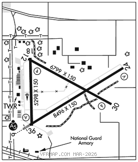
RWY 06–24: H8496X150 (ASPH–CONC–GRVD) S–120, D–250, 2S–175, 2D–550, 2D/2D2–1120 PCR 3280 F/D/X/T HIRL
RWY 06: MALSR. RVR–TM Road.
RWY 24: VASI(V4L)–GA 3.0° TCH 52′. RVR–MR
RWY 12–30: H6799X150 (ASPH–CONC–GRVD) S–120, D–250, 2S–175, 2D–550, 2D/2D2–1120 PCR 3250 F/D/X/T MIRL
RWY 12: Tree.
RWY 30: PAPI(P4L)–GA 3.0° TCH 51′.
RWY 18–36: H5298X150 (ASPH–GRVD) S–120, D–250, 2S–146, 2D–550, 2D/2D2–1035 PCR 1200 F/D/X/T MIRL
RWY 18: PAPI(P4L)–GA 3.0° TCH 53′. Trees.
RWY 36: VASI(V4L)–GA 3.0° TCH 58′. Pole.
LAND AND HOLD–SHORT OPERATIONS
LDG RWY HOLD–SHORT POINT AVBL LDG DIST
RWY 06 12–30 4800
RWY 12 06–24 4450
RWY 18 06–24 4450
RWY 24 12–30 3000
RWY 30 18–36 5050
RWY 36 12–30 4800
RUNWAY DECLARED DISTANCE INFORMATION
RWY 06: TORA–8496 TODA–8496 ASDA–8496 LDA–8496
RWY 12: TORA–6799 TODA–6799 ASDA–6799 LDA–6799
RWY 18: TORA–5298 TODA–5298 ASDA–5298 LDA–5298
RWY 24: TORA–8496 TODA–8496 ASDA–8496 LDA–8496
RWY 30: TORA–6799 TODA–6799 ASDA–6799 LDA–6799
RWY 36: TORA–5298 TODA–5298 ASDA–5298 LDA–5298
SERVICE: FUEL 100LL, JET A LGT ACTVT MALSR Rwy 06; MIRL Rwy 12–30 and 18–36; twy lgts Rwy 06–CTAF. When ATCT clsd HIRL Rwy 06–24 preset low intst; incr intst–CTAF. MILITARY– FUEL (NC–100LL, A)
AIRPORT REMARKS: Attended Mon–Fri continuously, Sat–Sun 1300–0330Z‡. When the twr is clsd, be alert for intermittent vehicular tfc in arpt ops areas. Birds; deer and other wildlife on and invof arpt. Snow removal ops in progress winter months; vehicle opr will be monitoring CTAF; acft ldg/dep use CTAF when twr clsd. PPR for AARF index B call arpt manager. Rwy 12 and Rwy 18 apch ends are closely aligned. Rwy 06 and Rwy 36 apch ends are closely aligned. Verify correct rwy and compass heading prior to departure. N ramp from Hangar B to Hangar G closed to acft over 12,500 lbs. Twy A restricted north of Twy G to acft wingspan of 86′ or less without prior arpt authority permission. Call 217–428–2423. Glider ops by written approval only; contact arpt manager 217–428–2423. Glider ops allowed on Rwys 06 and 30 only. No sod ops. For U.S. Customs call 217–425–4803.
AIRPORT MANAGER: 217-428-2423
WEATHER DATA SOURCES: ASOS (217) 429–0052
COMMUNICATIONS: CTAF 118.9 ATIS 126.35 UNICOM 122.95
RCO 122.3 (ST LOUIS RADIO)
ADDERS RCO 122.1R 117.2T (ST LOUIS RADIO)
®CHAMPAIGN APP/DEP CON 132.85 (1200–0500Z‡)
®CHICAGO CENTER APP/DEP CON 121.35 (0500–1200Z‡)
TOWER 118.9 (1200–0400Z‡) GND CON 121.75
CLEARANCE DELIVERY PHONE: For CD if una to ctc on FSS freq, ctc Chicago ARTCC 630-906-8921.
AIRSPACE: CLASS D svc 1200–0400Z‡; other times CLASS G.
RADIO AIDS TO NAVIGATION: NOTAM FILE DEC.
ADDERS (VH) (H) VORTAC 117.2 AXC Chan 119 N39°44.25′ W88°51.39′ 353° 5.8 NM to fld. 708/3E.
ELWIN NDB (LOMW) 275 DE N39°47.43′ W88°57.23′ 058° 4.9 NM to fld. 695/1W.
ILS/DME 110.9 I–DEC Chan 46 Rwy 06. Class IE. LOM ELWIN NDB. Unmonitored when ATCT closed. LOC back unusable byd 20° right of course.
COMM/NAV/WEATHER REMARKS: Emerg frequency 121.5 not avbl at twr.