CRESTON MUNI (CSQ)(KCSQ) 3 S UTC–6(–5DT) N41°01.29′ W94°21.80′
1300 B NOTAM FILE CSQ
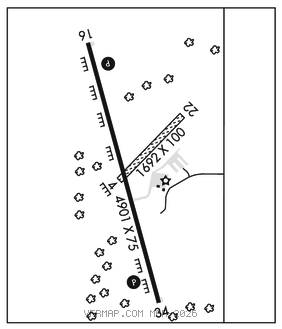
RWY 16–34: H4901X75 (CONC) S–15 PCN 13 F/D/X/T MIRL
RWY 16: REIL. PAPI(P2L)–GA 3.0° TCH 44′. Fence.
RWY 34: REIL. PAPI(P2L)–GA 3.0° TCH 44′. Tree.
RWY 04–22: 1692X100 (TURF)
SERVICE: S2 FUEL 100LL, JET A LGT ACTVT REIL Rwy 16 and Rwy 34; PAPIRwy 16 and Rwy 34; MIRL Rwy 16–34–CTAF. MIRL Rwy 16–34 preset low intst; incr intst–CTAF.
AIRPORT REMARKS: Attended Mon–Fri 1400–2300Z‡. Sat and Sun on call. Rwy 04–22 CLOSED durg winter. Remote ctl ops invof arpt. Rwy 04: Sharp drop at rwy end. Rwy end 04: marked with yellow cones. Rwy end 22: marked with yellow cones.
AIRPORT MANAGER: 641-278-0203
WEATHER DATA SOURCES: AWOS–3 124.75 (641) 782–6286.
COMMUNICATIONS: CTAF/UNICOM 122.8
®MINNEAPOLIS CENTER APP/DEP CON 125.65
CLEARANCE DELIVERY PHONE: For CD ctc Minneapolis ARTCC at 651-463-5588.
RADIO AIDS TO NAVIGATION: NOTAM FILE FOD.
LAMONI (VH) (H) VOR/DME 116.7 LMN Chan 114 N40°35.81′ W93°58.06′ 318° 31.2 NM to fld. 1142/7E.
DME unusable:
257°–290° blo 3,000′
291°–319°
320°–054° blo 3,000′
VOR unusable:
120°–122° byd 40 NM
123°–130°
257°–290° blo 3,000′
280°–290° byd 40 NM blo 3,000′
280°–290° byd 49 NM blo 18,000′
291°–319°
320°–054° blo 3,000′