CEDAR RAPIDS
THE EASTERN IOWA (CID)(KCID) 6 SW UTC–6(–5DT) N41°53.08′ W91°42.65′ 869 B ARFF Index–See Remarks NOTAM FILE CID
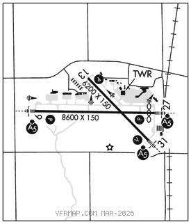
RWY 09–27: H8600X150 (CONC–GRVD) S–120, D–227, 2S–175, 2D–360 PCR 843 R/D/W/T HIRL
RWY 09: MALSR. PAPI(P4R)–GA 3.0° TCH 60′. RVR–TR
RWY 27: MALSR. PAPI(P4L)–GA 3.0° TCH 46′. RVR–TR Thld dsplcd 425′. Railroad.
RWY 13–31: H6200X150 (CONC–GRVD) S–120, D–172, 2S–175, 2D–360 PCR 742 R/D/W/T MIRL 0.4% up NW
RWY 13: REIL. PAPI(P4L)–GA 3.0° TCH 51′.
RWY 31: MALSR. VASI(V4L)–GA 3.0° TCH 50′.
RUNWAY DECLARED DISTANCE INFORMATION
RWY 09: TORA–8600 TODA–8600 ASDA–8175 LDA–8175
RWY 13: TORA–6200 TODA–6200 ASDA–6200 LDA–6200
RWY 27: TORA–8600 TODA–8600 ASDA–8600 LDA–8175
RWY 31: TORA–6200 TODA–6200 ASDA–6200 LDA–6200
SERVICE: S4 FUEL 100LL, JET A OX 1, 2, 3, 4 LGT When twr clsd ACTVT MALSR Rwy 09, 27, & 31; PAPI Rwy 09, 13 & 27; VASI Rwy 31; HIRL Rwy 09–27; MIRL Rwy 13–31; twy lgts–CTAF.
AIRPORT REMARKS: Attended Mon–Fri 1100–0530Z‡, Sat–Sun 1100–0530Z‡. Fuel: 100LL: self svc; W of GA apron. Fuel svc aft hr –319–366–1925. Birds on and invof arpt. When ATCT is clsd and during snow and ice events, all arrival/departure announce intentions on CTAF 5 minutes bfr rwy use. Personnel and equipment snow and ice removal monitor CTAF. Twy D is a non–movement southeast of arpt access road. Trml ramp non mov; call for push back not rqrd. Gate 5 & area n/nw clsd. Rwy 27 calm wind rwy. Class I, ARFF Index B. Index C level ARFF avbl; 48 hr ppr 319–731–5722.
AIRPORT MANAGER: 319-731-5711
WEATHER DATA SOURCES: ASOS (319) 558–5153 LAWRS. WSP.
COMMUNICATIONS: CTAF 118.7 ATIS 124.15 UNICOM 122.95
CEDAR RAPIDS RCO 122.2 (FORT DODGE RADIO)
®CEDAR RAPIDS APP/DEP CON 119.7 (091°–269°) 134.05 (270°–090°) (1100–0530Z‡)
CHICAGO CENTER APP/DEP CON 132.8 (0530–1100Z‡)
CEDAR RAPIDS TOWER 118.7 (1100–0530Z‡) GND CON 121.6 CLNC DEL 125.45
CLEARANCE DELIVERY PHONE: For CD if una to ctc on FSS freq, ctc Chicago ARTCC at 630-906-8921.
AIRSPACE: CLASS C svc ctc APP CON svc 1100–0530Z‡ other times CLASS E.
RADIO AIDS TO NAVIGATION: NOTAM FILE CID.
CEDAR RAPIDS (H) (H) VORW/DME 114.1 CID Chan 88 N41°53.25′ W91°47.14′ 088° 3.4 NM to fld. 876/5E.
ILS 109.3 I–CID Rwy 09. Class IE. Unmonitored when twr clsd. Auto pilot coupled apch NA blo 1,100 MSL.
ILS/DME 111.3 I–RRU Chan 50 Rwy 27. Class IT. Unmonitored when twr clsd. Glideslope unusable for coupled apchs blo 1,910′ MSL.