BUFFALO MUNI (CFE)(KCFE) 2 SE UTC–6(–5DT) N45°09.53′ W93°50.60′
968 B NOTAM FILE CFE
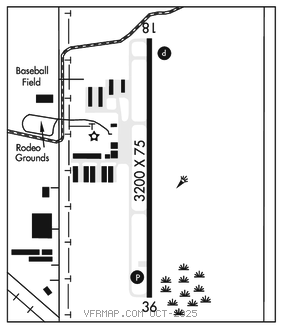
RWY 18–36: H3200X75 (ASPH) MIRL 0.4% up N
RWY 18: REIL. PAPI(P2L)–GA 3.0° TCH 42′. Trees.
RWY 36: REIL. PAPI(P2L)–GA 3.0° TCH 40′.
SERVICE: S4 FUEL 100LL LGT ACTIVATE REIL Rwy 18 and Rwy 36; PAPI Rwy 18 and Rwy 36; MIRL Rwy 18–36–CTAF; MIRL Rwy 18–36 preset low ints SS–SR, to incr ints and ACTIVATE–CTAF.
AIRPORT REMARKS: Attended dawn–dusk. Ultralight tfc on and invof arpt. Fuel avbl 24 hrs with credit card.
AIRPORT MANAGER: 763-682-0296
WEATHER DATA SOURCES: AWOS–3PT 120.45 (763) 684–0762.
COMMUNICATIONS: CTAF/UNICOM 122.8
®MINNEAPOLIS APP/DEP CON 126.5
GCO 121.725 (MINNEAPOLIS APCH and FLIGHT SERVICES)
CLEARANCE DELIVERY PHONE: For CD ctc Minneapolis Apch at 612-726-9086.
RADIO AIDS TO NAVIGATION: NOTAM FILE PNM.
GOPHER (VH) (H) VORTACW 117.3 GEP Chan 120 N45°08.74′ W93°22.39′ 266° 20.0 NM to fld. 877/6E.
VOR unusable:
061°–071° byd 40 NM
067°–080° byd 47 NM blo 3,000′
067°–080° byd 70 NM blo 12,000′
239°–277° byd 40 NM blo 18,000′