WAHPETON
HARRY STERN (BWP)(KBWP) 1 S UTC–6(–5DT) N46°14.66′ W96°36.43′ 968 B NOTAM FILE GFK
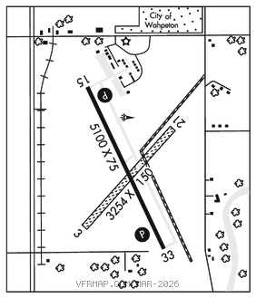
RWY 15–33: H5100X75 (CONC) S–20 MIRL
RWY 15: REIL. PAPI(P2L)–GA 3.0° TCH 42′. Trees.
RWY 33: REIL. PAPI(P2L)–GA 3.0° TCH 26′. Trees.
RWY 03–21: 3254X150 (TURF)
RWY 03: Trees.
SERVICE: S4 FUEL 100LL, JET A LGT MIRL Rwy 15–33 preset low intst, to incr intst and ACTVT REIL Rwy 15 and 33; PAPI Rwy 15 and 33–CTAF.
AIRPORT REMARKS: Attended Mon–Fri 1400–2300Z‡, Sat–Sun on call. For service after hrs call arpt manager 701–361–0230. Deer and birds on or invof arpt. 100LL 24 hr self–service with credit card. Cfm aprt conds in winter months bfr use call 701–642–5777. Rwy 03–21 clsd winter months. Rwy 03 safety area cultivated, uneven dirt, soft when wet. Rwy 03–21 mkd with edge and corner dalgt metal mkrs painted orange.
AIRPORT MANAGER: 701-642-5777
WEATHER DATA SOURCES: AWOS–3 127.875 (701) 642–9800.
COMMUNICATIONS: CTAF/UNICOM 123.0
FARGO RCO 122.4 (GRAND FORKS RADIO)
®MINNEAPOLIS CENTER APP/DEP CON 127.35
CLEARANCE DELIVERY PHONE: For CD ctc Minneapolis ARTCC at 651-463-5588.
RADIO AIDS TO NAVIGATION: NOTAM FILE FAR.
FARGO (VH) (DH) VORW/DME 116.2 FAR Chan 109 N46°45.20′ W96°51.08′ 153° 32.2 NM to fld. 909/9E.