BISMARCK MUNI (BIS)(KBIS) P (ARNG) 3 SE UTC–6(–5DT) N46°46.36′ W100°44.74′
1661 B Class I, ARFF Index B NOTAM FILE BIS MON Airport
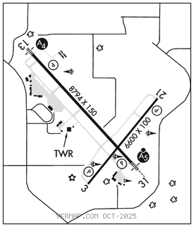
RWY 13–31: H8794X150 (ASPH–CONC–GRVD) S–130, D–180, 2D–340 PCN 100R/B/X/T HIRL
RWY 13: MALS. PAPI(P4L)–GA 3.0° TCH 58′. RVR–R Pole.
RWY 31: MALSR. PAPI(P4L)–GA 3.0° TCH 48′. RVR–T
RWY 03–21: H6600X100 (ASPH–GRVD) S–130, D–180, 2D–340 PCN 26 F/A/W/T HIRL
RWY 03: REIL. PAPI(P4L)–GA 3.0° TCH 48′.
RWY 21: REIL. PAPI(P4L)–GA 3.0° TCH 48′.
RUNWAY DECLARED DISTANCE INFORMATION
RWY 03: TORA–6600 TODA–6600 ASDA–6600 LDA–6600
RWY 13: TORA–8794 TODA–8794 ASDA–8794 LDA–8794
RWY 21: TORA–6600 TODA–6600 ASDA–6600 LDA–6600
RWY 31: TORA–8794 TODA–8794 ASDA–8794 LDA–8794
SERVICE: S4 FUEL 100LL, JET A OX1, 2 LGT When ATCT clsd HIRL Rwy 13–31 and 03–21 preset med intst; PAPI Rwy 13, 31, 03, and 21 on; actvt MALS Rwy 13 and MALSR Rwy 31 –CTAF. MILITARY–FUEL J8(Mil), A+ (C701–258–5024), (NC–100LL – Fone C701–223–4754 or C701–258–5024).
AIRPORTREMARKS: Attended continuously. Deer, coyotes and birds on and invof arpt. For fuel call 701–223–4754 or 701–258–5024. Rwy 03 rwy end safety area nstd. Rwy 21 rwy end safety area nstd.
MILITARY REMARKS: ARNG Opr 1200–2130Z‡ Mon–Fri exc hol, PPR 24 hr PN rqr DSN 373–4071/70, C701–333–4071/70. FW PAX trml lctd in SE hgr.
AIRPORT MANAGER: 701-355-1808
WEATHER DATA SOURCES: ASOS (701) 922–9747 LAWRS.
COMMUNICATIONS: CTAF 118.3 ATIS 119.35 UNICOM 122.95
RCO 122.2 (GRAND FORKS RADIO)
®APP/DEP CON 126.3 (1200–0600Z‡)
®MINNEAPOLIS CENTER APP/DEP CON 135.25 (0600–1200Z‡)
TOWER 118.3 (1200–0600Z‡) GND CON 121.9
CLEARANCE DELIVERY PHONE: For CD if una to ctc on FSS freq, ctc Minneapolis ARTCC at 651-463-5588.
AIRSPACE: CLASS D svc 1200–0600Z‡; other times CLASS E.
RADIO AIDS TO NAVIGATION: NOTAM FILE BIS.
(VL) (DH) VORW/DME 115.65 BIS Chan 103(Y) N46°45.71′ W100°39.92′ 269° 3.4 NM to fld. 1854/12E.
ILS 111.5 I–BZX Rwy 13. Class IE. Unmonitored when ATCT clsd.
ILS/DME 110.3 I–BIS Chan 40 Rwy 31. Class IB. Glideslope unusable for auto pilot coupled apchs blo 2,680′. LOC and glideslope unmonitored when ATCT clsd.
ASR (1200–0600Z‡)