BAUDETTE INTL (BDE)(KBDE) 1 N UTC–6(–5DT) N48°43.82′ W94°36.66′
1085 B AOE NOTAM FILE BDE
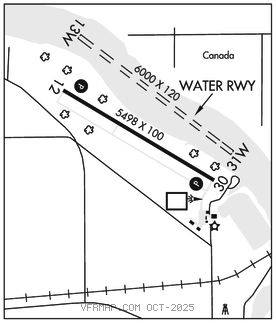
RWY 12–30: H5498X100 (ASPH–GRVD) S–30 HIRL
RWY 12: REIL. PAPI(P4L)–GA 3.0° TCH 47′.
RWY 30: REIL. PAPI(P4L)–GA 3.0° TCH 49′. Trees.
SERVICE: S4 FUEL 100LL, JET A LGT ACTVT or incr intst REIL Rwy 12 and 30; PAPI Rwy 12 and 30; HIRL Rwy 12–30–CTAF. HIRL Rwy 12–30 preset low intst.
AIRPORT REMARKS: Attended Apr–Oct 1400–0200Z‡, Attended Nov–Mar 1400–2300Z‡. For attendant otr times call amgr or 218–839–6488. Gulls and otr birds on and invof arpt. 100LL aft hrs call amgr. Seaplane landing area adjacent north of land facility. Flight notification service (ADCUS) avbl.
AIRPORT MANAGER: 218-839-6488
WEATHER DATA SOURCES: ASOS 126.775 (218) 634–3080.
COMMUNICATIONS: CTAF/UNICOM 122.8
RCO 122.4 (PRINCETON RADIO)
®MINNEAPOLIS CENTER APP/DEP CON 134.75
CLEARANCEDELIVERYPHONE:For CD if una to ctc on FSS freq, ctc Minneapolis ARTCC at 651-463-5588.
RADIO AIDS TO NAVIGATION: NOTAM FILE BDE.
(L) DME 111.6 BDE Chan 53 N48°43.37′ W94°36.44′ at fld. 1083.
DME unusable:
100°–265° byd 35 NM blo 3,500′
295°–310° byd 35 NM blo 3,500′
ILS 108.3 I–BDE Rwy 30. Class IT. Autopilot cpd apchs NA blw 1,360′ MSL. LOC unmonitored. • • • • • • • • • • • • • • • • • •
WATERWAY 13W–31W: 6000X120 (WATER)