BENSON MUNI (BBB)(KBBB) 2 W UTC–6(–5DT) N45°19.92′ W95°39.04′
1039 B NOTAM FILE BBB
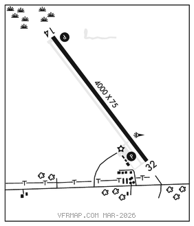
RWY 14–32: H4000X75 (ASPH) S–40, D–50 MIRL
RWY 14: REIL. PAPI(P4L)–GA 3.0° TCH 40′. Brush. Rgt tfc.
RWY 32: REIL. PAPI(P4L)–GA 3.0° TCH 41′. Trees.
SERVICE: S2 FUEL 100LL, JET A LGT MIRL Rwy 14–32 preset low ints, to incr ints and ACTIVATE REIL Rwy 14 and Rwy 32; PAPI Rwy 14 and Rwy 32; MIRL Rwy 14–32–CTAF. Rwy 14 PAPI unusable byd 2 NM.
AIRPORT REMARKS: Unattended. Self svc fuel avbl 24 hrs with credit card. Category C and D acft ops prohibited.
AIRPORT MANAGER: 320-843-4775
WEATHER DATA SOURCES: AWOS–3PT 118.45 (320) 843–3242.
COMMUNICATIONS: CTAF/UNICOM 122.8
MINNEAPOLIS CENTER APP/DEP CON 125.5
CLEARANCE DELIVERY PHONE: For CD ctc Minneapolis ARTCC at 651-463-5588.
RADIO AIDS TO NAVIGATION: NOTAM FILE MOX.
MORRIS (T) (T) VORW/DME 109.6 MOX Chan 33 N45°33.93′ W95°58.16′ 131° 19.4 NM to fld. 11305E. VDME unmonitored.