BAD AXE
HURON CO MEML (BAX)(KBAX) 1 S UTC–5(–4DT) N43°46.81′ W82°59.13′ 764 B NOTAM FILE BAX
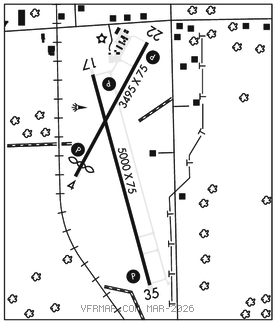
RWY 17–35: H5000X75 (ASPH–GRVD) PCN 19 F/C/X/T MIRL
RWY 17: REIL. PAPI(P4L)–GA 3.0° TCH 40′. Trees.
RWY 35: REIL. PAPI(P4L)–GA 3.0° TCH 41′.
RWY 04–22: H3495X75 (ASPH) S–16 MIRL
RWY 04: PAPI(P4L)–GA 3.0° TCH 25′. Thld dsplcd 300′. Railroad.
RWY 22: PAPI(P4L)–GA 3.5° TCH 45′. Trees.
SERVICE: FUEL 100LL, JET A+ LGT MIRL Rwy 04–22 and Rwy 17–35 opr dusk–0230Z‡; to increase ints and after 0230Z‡ ACTIVATE–CTAF. ACTIVATE PAPI Rwy 04, Rwy 17, Rwy 22, Rwy 35; REIL Rwy 17 and Rwy 35–CTAF.
AIRPORT REMARKS: Attended Mon–Fri 1330–2130Z‡. Arpt unattended weekends and major holidays. Deer and lrg birds on and invof arpt. Admin bldg aces–press V, then simultaneous III & II, then I. Turbo prop and jet landing fee waived with fuel purchase.
AIRPORT MANAGER: 989-269-6511
WEATHER DATA SOURCES: AWOS–3P 118.6 (989) 269–4137.
COMMUNICATIONS: CTAF/UNICOM 123.075
BAD AXE RCO 122.2 (LANSING RADIO)
®CLEVELAND CENTER APP/DEP CON 127.7
CLEARANCE DELIVERY PHONE: For CD ctc Cleveland ARTCC at 440-774-0224/0490.
RADIO AIDS TO NAVIGATION: NOTAM FILE MBS.
SAGINAW (VL) (DH) VORW/DME 114.35 MBS Chan 90(Y) N43°31.90′ W84°04.64′ 075° 49.8 NM to fld. 663/3W.
DME unusable:
185°–200° byd 14 NM
VOR unusable:
145°–185° byd 40 NM
336°–338° byd 40 NM