AUSTIN MUNI (AUM)(KAUM) 2 E UTC–6(–5DT) N43°39.76′ W92°55.98′
1234 B NOTAM FILE AUM MON Airport
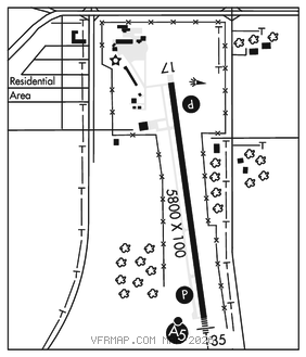
RWY 17–35: H5800X100 (CONC) S–100, D–135 PCN 48 R/C/W/T HIRL
RWY 17: REIL. PAPI(P4L)–GA 3.0° TCH 41′. Trees.
RWY 35: MALSR. PAPI(P4L)–GA 3.0° TCH 42′.
SERVICE: S4 FUEL 100LL, JET A LGT ACTIVATE MALSR Rwy 35; REIL Rwy 17; PAPI Rwy 17 and Rwy 35; HIRL Rwy 17–35 dalgt–CTAF. HIRL Rwy 17–35 preset low ints at night, to increase ints–CTAF. FUEL: Aft hrs, ctc FBO 507–433–1813.
AIRPORT REMARKS: Attended Mon–Fri 1400–2300Z‡, Sat 1400–2200Z‡, Sun 1500–2100Z‡. Migratory waterfowl and deer invof arpt.
AIRPORT MANAGER: 507-433-1813
WEATHER DATA SOURCES: AWOS–3PT 119.025 (507) 433–6667.
COMMUNICATIONS: CTAF/UNICOM 122.7
RCO 122.5 (PRINCETON RADIO
®ROCHESTER APP/DEP CON 119.8 (1100–0400Z‡)
®MINNEAPOLIS CENTER APP/DEP CON 132.35 (0400–1100Z‡)
CLEARANCE DELIVERY PHONE: For CD ctc Rochester Apch at 507-424-8111.
RADIO AIDS TO NAVIGATION: NOTAM FILE RST.
ROCHESTER (L) (DH) VORW/DME 112.0 RST Chan 57 N43°46.97′ W92°35.82′ 239° 16.3 NM to fld. 1393/5E.
ILS 110.55 I–AUM Rwy 35. Class IB.