ANTHONY MUNI (ANY)(KANY) 3 NW UTC–6(–5DT) N37°09.59′ W98°04.77′
1343 B NOTAM FILE ICT
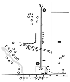
RWY 18–36: H5002X75 (CONC) PCN 11 R/C/X/U LIRL
RWY 18: PAPI(P2L)–GA 3.0° TCH 44′.
RWY 36: PAPI(P2L)–GA 3.0° TCH 46′. Tree.
RWY 10–28: 2212X60 (TURF) 0.4% up SE
RWY 10: Trees.
RWY 28: Road.
SERVICE: FUEL 100LL LGT LIRL Rwy 18–36 preset low intst; to incr intst and ACTVT PAPI Rwy 18 and 36–CTAF.
AIRPORTREMARKS: Unattended. 100LL: Fuel self svc. Terminal bldg access code 134. Rwy 10–28 soft after rain. Rwy 10–28 mowed 300 ft wide. NOTE: See Special Notices–Model Rocket Activity.
AIRPORT MANAGER: 620-842-5434
WEATHER DATA SOURCES: AWOS–3PT 119.575 (620) 842–4345.
COMMUNICATIONS: CTAF/UNICOM 122.8
ANTHONY RCO 122.4 (WICHITA RADIO)
®WICHITA APP/DEP CON 126.7
CLEARANCE DELIVERY PHONE: For CD if una to ctc on FSS freq, ctc Wichita appch at 316-350-1520
RADIO AIDS TO NAVIGATION: NOTAM FILE ICT.
(L) TACAN Chan 76 ANY (112.9) N37°09.54′ W98°10.25′ 082° 4.4 NM to fld. 1392/7E.
TACAN AZIMUTH unusable:
263°–273° byd 25 NM blo 4,000′