ANOKA CO/BLAINE (JANES FLD) (ANE)(KANE) 10 N UTC–6(–5DT) N45°08.69′ W93°12.61′
912 B NOTAM FILE ANE
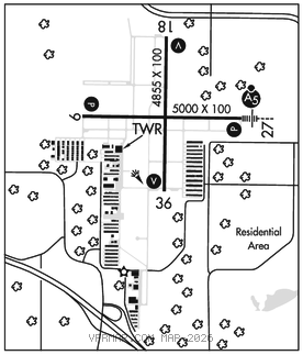
RWY 09–27: H5000X100 (ASPH–GRVD) S–23, D–60 HIRL
RWY 09: REIL. PAPI(P4L)–GA 3.0° TCH 25′.
RWY 27: MALSR. PAPI(P4L)–GA 3.0° TCH 50′. Rgt tfc.
RWY 18–36: H4855X100 (ASPH) S–23, D–60 MIRL
RWY 18: REIL. VASI(V4L)–GA 3.0° TCH 48′. Rgt tfc.
RWY 36: REIL. VASI(V4L)–GA 3.0° TCH 48′.
SERVICE: S4 FUEL 100LL, JET A OX 3, 4 LGT ACTIVATE or incr intst MALSR Rwy 27; REIL Rwy 09, 18, and 36; PAPI Rwy 09 and 27; VASI Rwy 18 and 36; HIRL Rwy 09–27; MIRL Rwy 18–36–CTAF. HIRL Rwy 09–27 and MIRL 18–36 preset low intst.
NOISE: Voluntary noise abatement procs in efct. See arpt website for more info.
AIRPORT REMARKS: Attended continuously. Deer, birds and wildlife on and invof arpt. 100LL fuel avbl H24 via credit card at Lynx South ramp. Jet A avbl at FBOs subj ldg fee ctc FBO. When atct is clsd snow removal oprs mnt CTAF. Rwy 27 calm wind rwy when atct is clsd. Ldg fee for turbine acft.
AIRPORT MANAGER: 763-717-0001
WEATHER DATA SOURCES: AWOS–3 (763) 780–9025 LAWRS.
COMMUNICATIONS: CTAF 132.4 ATIS 120.625 UNICOM 122.95
RCO 122.6 (PRINCETON RADIO)
®MINNEAPOLIS APP/DEP CON 126.5
MINNEAPOLIS APCH CLNC DEL 121.85 (when twr clsd)
TOWER 132.4 (1300–0300Z‡ Oct–Apr; 1300–0400Z‡ May–Sep)
GND CON 121.85 CLNC DEL 121.3
AIRSPACE: CLASS D svc 1300–0300Z‡ Oct–Apr, 1300–0400Z‡ May–Sep; other times CLASS E.
RADIO AIDS TO NAVIGATION: NOTAM FILE PNM.
GOPHER (VH) (H) VORTACW 117.3 GEP Chan 120 N45°08.74′ W93°22.39′ 084° 6.9 NM to fld. 877/6E.
VOR unusable:
025°–080° blo 5,000′
061°–071° byd 40 NM
067°–080° byd 47 NM blo 3,000′
067°–080° byd 70 NM blo 12,000′
239°–277° byd 40 NM blo 18,000′
240°–260° byd 5 NM
275°–285° byd 10 NM blo 4,000′
330°–345° byd 13 NM blo 3,000′
TACAN AZIMUTH unusable:
025°–080° blo 5,000′
145°–155° byd 37 NM blo 3,800′
230°–250° byd 38 NM blo 3,400′
275°–285° byd 10 NM blo 4,000′
330°–345° byd 13 NM blo 3,000′
DME unusable:
145°–155° byd 37 NM blo 3,800′
275°–285° byd 10 NM blo 4,000′
330°–345° byd 13 NM blo 3,000′
ILS/DME 111.15 I–ANE Chan 48(Y) Rwy 27. Class IT. Autopilot cpd apch NA blw 1,700′.