ANDERSON RGNL (AND)(KAND) 3 SW UTC–5(–4DT) N34°29.68′ W82°42.56′
782 B NOTAM FILE AND
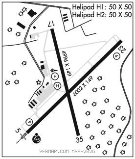
RWY 05–23: H6002X149 (ASPH–GRVD) S–40, D–58, 2S–85, 2D–109 PCN 15 F/C/Y/T HIRL
RWY 05: MALSR. PAPI(P4L)–GA 3.0° TCH 49′. Trees.
RWY 23: PAPI(P4L)–GA 3.0° TCH 45′. Trees.
RWY 17–35: H4996X149 (ASPH) S–17.5, D–28 PCN 6 F/C/X/T 0.9% up N
RWY 17: Trees.
RWY 35: Trees.
SERVICE: S4 FUEL 100LL, JET A OX 4 LGT ACTVT MALSR Rwy 05; HIRL Rwy 05–23; perimeter lgtshelipads H1 and H2–CTAF. PAPI Rwy 05 and Rwy 23 opr consly.
AIRPORT REMARKS: Attended 1230–0030Z‡. Call 864–964–5656 for svc. Arpt unatndd Thanksgiving, Christmas, New Years Day and Easter. Parachute jumping. Wildlife on and invof arpt, more active at dusk and dawn. Aerobatic practice area on and invof arpt. Aft hrs 100LL fuel avbl with credit card. Rwy 17–35 widespread cracks. Profile of Rwy 05–23 restricts vis from thld Rwy 05 to thld Rwy 23. Lndg fee. No ramp fee for piston sngls.
AIRPORT MANAGER: 864-260-4163
WEATHER DATA SOURCES: ASOS 120.675 (864) 226–9522.
COMMUNICATIONS: CTAF 123.6
RCO 122.2 (ANDERSON RADIO)
®GREER APP/DEP CON 118.8 (1100–0445Z‡)
ATLANTA CENTER APP/DEP CON 127.5 (0445–1100Z‡)
CLEARANCE DELIVERY PHONE: For CD if una to ctc on FSS freq, ctc Greer Apch at 864-877-8275, when Apch clsd ctc Atlanta ARTCC at 770-210-7692.
AIRSPACE: CLASS E.
RADIO AIDS TO NAVIGATION: NOTAM FILE AND.
ELECTRIC CITY (L) (L) VORTACW 108.6 ELW Chan 23 N34°25.15′ W82°47.08′ 040° 5.9 NM to fld. 736/0E.
ILS/DME 111.9 I–AND Chan 56 Rwy 05. Class IA. • • • • • • • • • • • • • • • • • •
HELIPAD H1: H50X50 (CONC) S–30 PERIMETER LGTS
HELIPAD H2: H50X50 (CONC) S–30 PERIMETER LGTS
HELIPORT REMARKS: Hel with skids are rstd to land on helipads or grassed areas.