ALAMOGORDO
ALAMOGORDO–WHITE SANDS RGNL (ALM)(KALM) 4 SW UTC–7(–6DT) N32°50.37′ W105°59.47′ 4200 B NOTAM FILE ALM
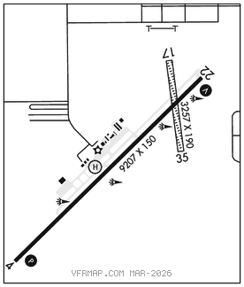
RWY 04–22: H9207X150 (ASPH–PFC) S–54, D–74, 2S–94, 2D–120 PCN 48 F/B/X/T MIRL
RWY 04: REIL. PAPI(P4R)–GA 3.0° TCH 55′. Rgt tfc. 0.8% up.
RWY 22: REIL. VASI(V2L)–GA 3.0° TCH 40′. 0.8% down.
RWY 17–35: 3257X190 (DIRT) 0.6% up N
RWY 17: Brush.
RWY 35: Brush. Rgt tfc.
RUNWAY DECLARED DISTANCE INFORMATION
RWY 04: TORA–9207 TODA–9207 ASDA–9207 LDA–9207
RWY 22: TORA–9207 TODA–9207 ASDA–9207 LDA–9207
SERVICE: S4 FUEL 100LL, JET A1+ OX 1 LGT ACTVT PAPI Rwy 04, VASI Rwy 22, MIRL Rwy 04–22–CTAF. MIRL Rwy 04–22 preset med intst, incr ints–CTAF.
AIRPORT REMARKS: Attended 1400–0000Z‡. Aft hr–575–437–2474. 8000 ft mts 4 NM E. Mil, glider, ultralight and unmanned aerial vehicle act on and invof arpt. VFR ops btn El Paso and Alamogordo–White Sands flw and rmn W of Hwy 54 and train tracks, rmn clear of rstrd asp. Rwy 17–35 ops durg wet cond NA, for cond–575–551–6245. Holloman Rapcon IFR sdby svc 60 min recall–575–572–7575. Rwy 22 calm wind rwy when less than 5 kts. 200′ blast pads mkd by chevrons.
AIRPORT MANAGER: 575-439-4110
WEATHER DATA SOURCES: AWOS–3 127.825 (575) 439–4112.
COMMUNICATIONS: CTAF/UNICOM 122.8
RCO 122.4 (ALBUQUERQUE RADIO)
®HOLLOMAN APP CON 120.6 (Mon 0900Z‡ thru Fri 0100Z‡, Clsd Sat, Sun and holidays)
®HOLLOMAN DEP CON 128.1 (Mon 0900Z‡ thru Fri 0100Z‡, Clsd Sat, Sun and holidays)
®ALBUQUERQUE CENTER APP/DEP CON 132.65 257.6 (When Holloman apch control clsd) 24 hrs Sat, Sun and Holidays.
CLEARANCE DELIVERY PHONE: For CD if una to ctc on FSS freq, ctc Albuquerque ARTCC at 505-856-4561.
RADIO AIDS TO NAVIGATION: NOTAM FILE ALM.
BOLES (L) DME 113.65 BWS Chan 83(Y) N32°49.28′ W106°00.79′ 046° 1.6 NM to fld. 4106.
DME unusable:
041°–140° byd 16 NM
• • • • • • • • • • • • • • • • • •
HELIPAD H1: H105X135 (ASPH)