ALBERT LEA MUNI (AEL)(KAEL) 3 N UTC–6(–5DT) N43°40.88′ W93°22.09′
1261 B TPA–2001(740) NOTAM FILE AEL
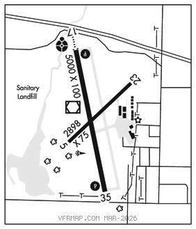
RWY 17–35: H5000X100 (ASPH) S–19, D–29 MIRL
RWY 17: ODALS. REIL. PAPI(P4L)–GA 3.0° TCH 30′.
RWY 35: REIL. PAPI(P4L)–GA 3.0° TCH 30′. Road.
RWY 05–23: H2898X75 (ASPH)
SERVICE: S2 FUEL 100LL, JET A, MOGAS LGT ACTIVATE ODALS Rwy 17; REIL Rwy 17 and Rwy 35; PAPI Rwy 17 and Rwy 35; MIRL Rwy 17–35–CTAF. MIRL Rwy 17–35 preset to low SS–SR, to incr ints–CTAF.
AIRPORT REMARKS: Attended 1400–2300Z‡. For svc aft hrs call 507–826–3451. 100LL and MOGAS fuel avbl 24 hr with credit card. Gliders and helicopters use turf parallel to Rwy 17–35 on east side and approach area to Rwy 23. TV tower 9.5 NM southeast. Multiple transitional obstructions Rwy 05 and Rwy 35. Tie down fee waived with fuel purchase. Lndg fee.
AIRPORT MANAGER: 507-373-0608
WEATHER DATA SOURCES: AWOS–3PT 119.575 (507) 377–1583.
COMMUNICATIONS: CTAF/UNICOM 123.0
®ROCHESTER APP/DEP CON 119.8 (1100–0500Z‡)
®MINNEAPOLIS CENTER APP/DEP CON 132.35 (0500–1100Z‡)
CLEARANCE DELIVERY PHONE: For CD ctc Rochester Apch at 507-424-8111.
RADIO AIDS TO NAVIGATION: NOTAM FILE AEL.
(T) (T) VORW/DME 109.8 AEL Chan 35 N43°40.90′ W93°22.25′ at fld. 1252/1E. VOR/DME unmonitored.