WALLACE–PENDER (ACZ)(KACZ) 1 SW UTC–5(–4DT) N34°43.07′ W78°00.23′
38 B NOTAM FILE RDU
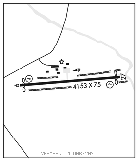
RWY 09–27: H4153X75 (ASPH) S–12.5 MIRL
RWY 09: PAPI(P2L)–GA 3.13° TCH 40′. Thld dsplcd 149′.
RWY 27: PAPI(P2L)–GA 3.53° TCH 44′. Thld dsplcd 151′.
SERVICE: S4 FUEL 100LL, JET A1+ LGT ACTVT MIRLs Rwy 09–27–CTAF. PAPIs opr consly.
NOISE: Noise abatement procedures in eff, call amgr 910–271–8955.
AIRPORT REMARKS: Attended Mon–Sat 1300–2200Z‡, Sun 1800–2300Z‡. 100LL 24 hr self service fuel with credit card. 24 hr access to pilots lounge. Wallace–Pender Arpt CLOSED to touch and go/practice apchs 0200–1100Z‡ dly. Arpt clsd to mil acft except 1 hr PPR. Mil acft limit dla on rwy to avoid damage to rwy surfaces. 5 ft ditch 135 ft right of cntrln Rwy 09. 7 ft ditch 140 ft left of cntrln Rwy 27. Rwy 27 safety area has 20 ft depressions/creek 160 ft fr thr both sides cntrln.
AIRPORT MANAGER: 910-285-6642
WEATHER DATA SOURCES: AWOS–3P 121.07 (910) 285–0419.
COMMUNICATIONS: CTAF/UNICOM 122.8
®WILMINGTON APP/DEP CON 135.75 (1100–0400Z‡)
®WASHINGTON CENTER APP/DEP CON 124.025 (0400–1100Z‡)
CLEARANCEDELIVERYPHONE:For CD ctc Wilmington Apch at 910-815-4676, or when Apch clsd ctc Washington ARTCC at 703-771-3587.
RADIO AIDS TO NAVIGATION: NOTAM FILE ISO.
KINSTON (VL) (L) VORTAC 117.5 ISO Chan 122 N35°22.26′ W77°33.50′ 214° 44.9 NM to fld. 705W.
VOR unusable:
020°–025° byd 40 NM
040°–115° byd 40 NM
145°–155° byd 40 NM
175°–185° byd 40 NM
183°–215° byd 30 NM blo 5,000′
200°–206° byd 40 NM
207°–214° byd 59 NM
215°–238° blo 3,500′
215°–238° byd 6 NM
238°–258° byd 30 NM blo 5,000′
239°–265° byd 40 NM
280°–290° byd 40 NM
295°–308° byd 40 NM
309°–319° byd 31 NM
320°–325° byd 40 NM
335°–340° byd 40 NM
345°–347° byd 40 NM
348°–358° byd 20 NM
TACAN AZIMUTH unusable:
183°–215° byd 30 NM blo 5,000′
DME unusable:
183°–215° byd 30 NM blo 5,000′