MONTAGUE
TURNERS FALLS (0B5) 3 N UTC–5(–4DT) N42°35.50′ W72°31.38′ 359 B NOTAM FILE BTV
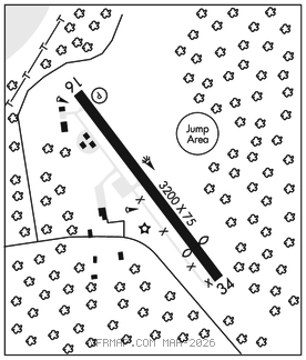
RWY 16–34: H3200X75 (ASPH) S–30 MIRL
RWY 16: REIL. PAPI(P4L)–GA 3.0° TCH 40′. Trees.
RWY 34: Thld dsplcd 550′. Trees.
SERVICE: S4 FUEL 100LL, JET A1 LGT ACTIVATE REIL Rwy 16 and MIRL Rwy 16–34–CTAF.
AIRPORT REMARKS: Attended Mon–Fri 1300–2100Z‡. Parachute Jumping. Wildlife and birds invof arpt. Fuel cart ctc amgr. Rwy 16 is calm wind rwy. Cold temperature airport. Altitude correction required at or below –25C.
AIRPORT MANAGER: 413-863-0044
COMMUNICATIONS: CTAF/UNICOM 123.0
BOSTON CENTER APP/DEP CON 123.75
CLEARANCE DELIVERY PHONE: For CD ctc Boston ARTCC at 603-879-6859.
RADIO AIDS TO NAVIGATION: NOTAM FILE BDR.
GARDNER (VL) (L) VOR/DME 116.95 GDM Chan 116(Y) N42°32.76′ W72°03.49′ 292° 20.8 NM to fld. 128014W.